
Israel Can’t Hide Evidence of Its Occupation Anymore
- The Tech Platform

- Aug 8, 2020
- 4 min read
For more than 20 years, an obscure U.S. law concealed satellite imagery of Israel’s activities in the occupied territories. Because of an abrupt reversal, satellite technology can now be used to defend Palestinians’ human rights.

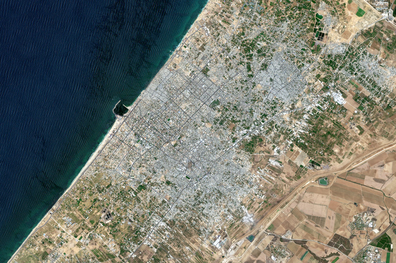
A satellite image shows Gaza City and the Jabalia Refugee Camp in the northern Gaza Strip on July 10, 2018. ORBITAL HORIZON/COPERNICUS SENTINEL DATA 2018/GALLO IMAGES/GETTY IMAGES
For the past two decades, there has been a general—and mostly unchallenged—understanding that satellite imagery is restricted over Israel and the Palestinian and Syrian territories it occupies. This was due to a 1996 U.S. regulation known as the Kyl-Bingaman Amendment (KBA) which has limited the quality and availability of high-resolution satellite imagery produced by U.S. companies covering Israel (and by implicit extension, the occupied Palestinian territories and the occupied Golan Heights). The result is that publicly available imagery on platforms such as Google Earth has been deliberately coarse and blurred.
On June 25, following two years of sustained pressure from academia and civil society, the 97-word KBA was unexpectedly reformed, making higher-resolution satellite imagery legally accessible and readily available to all. The news, though welcome, raises certain questions: First, what were the effects of the KBA? Second, since satellite imagery has advanced significantly both in scale and diversity in the 24 years since the KBA was passed, why did it take so long to reverse?
The KBA was a byproduct of the aftermath of the Cold War, when the satellite imagery industry was still young. President Bill Clinton sought to refashion technology formerly used for espionage for a wider, commercial usage. He also moved to declassify U.S. spy satellite imagery from the 1960s and 1970s.
The combination of commercialization and declassification rang alarm bells in some quarters. Israel, driven by a desire for Cold War secrecy, lobbied Congress for stricter regulation, which led to the passing of the KBA: the U.S. government’s only censorship of imagery of any part of the world.
The legislation, implemented under the guise of protecting Israel’s national security, was actually more an act of censorship.
The legislation, implemented under the guise of protecting Israel’s national security, was actually more an act of censorship.After all, high-resolution satellite imagery allows researchers to understand, identify, and document landscape changes. The National Oceanic and Atmospheric Administration (NOAA) within the U.S.
Department of Commerce is responsible for implementing the regulations concerning remote sensing. Since the KBA did not specify the resolution permitted, the regulation was fixed at 2 meters per pixel.
By contrast, commercial imagery available today is more likely to range from 0.25-0.6 meters per pixel. It is the difference between seeing the broad outline of a large building and being able to see individual vehicles parked outside. It is possible to identify substantial changes in land use (for instance, the building of city-size settlements or the bulldozing of Palestinian structures) at the two-meter limit, but subtler changes—such as the growth of outpost settlements or small military emplacements—are harder to discern. For 24 years, the legislation obfuscated the damaging effects of the Israeli occupation by literally hiding them from view.
The censorship over Israel and the occupied territories has had negative archeological, geographical, and humanitarian implications. Arguably the most glaring of these has been its effects on monitoring the decades long Israeli occupation—including documenting home demolitions, territorial disputes, and settlement growth. Lower-resolution imagery has forestalled efforts to challenge and verify human rights violations, especially in hard-to-reach areas such as the Gaza Strip, which has been under siege since 2007. For instance, high-resolution satellite imagery could be used by investigative teams such as Forensic Architecture to identify the exact point from which a fatal shot was fired at unarmed protesters.
Although the KBA legislation only applied to U.S. companies, the biggest players in the global market—firms such as Maxar and Planet, and online open-access points such as Google and Bing—are American. Even as foreign companies began producing high-resolution imagery during the 2010s, U.S. dominance meant that, in reality, the KBA was applied on a de facto global scale.
The KBA has harmed U.S. business interests, since U.S. technology companies are not able to compete internationally because of restrictions on the sale of detailed imagery.
Despite instances of muted resistance to the two-meter limitation from tech giants such as Google Earth and Bing Maps over the years, as well as calls for the KBA’s revocation, there was, until recently, little attempt at reform. The censorship of satellite imagery over Israel and the occupied territories mutated into one of those seemingly immovable exceptions that define the Palestinian-Israeli dispute.
The KBA has also had an adverse impact on scientific research. Satellite imagery is a crucial tool for surveying and monitoring, and low-resolution imagery does not have the required level of detail for a discipline such as archaeology to track changes to heritage sites or looting pits. Similarly, climate change assessments frequently rely on data from satellite imagery, which has not been available despite the dangers posed by climate change to the region.
Taken together, these effects amounted to a deliberate blind spot created by the KBA, which directly prohibited the vital work of researchers, academics, and humanitarians.
Source: Paper.li


Comments