
Complete Roman City Mapped Using Advanced Ground-Penetrating Radar Technology
- The Tech Platform

- Jun 12, 2020
- 3 min read

Researchers have mapped an entire Roman city using advanced ground-penetrating radar (GPR) technology in what they describe as an archaeological first.
A team from Ghent University in Belgium and the University of Cambridge in the U.K. conducted the first high-resolution GPR survey of a complete Roman settlement—Falerii Novi, located just over 30 miles of Rome in what is now the region of Lazio in Italy.
The technique the researchers used revealed the entire layout of the city—which remains deep underground—as well as a bath complex, a market, a temple, an impressive public monument, and even a large system of water pipes, without the need for any excavations, according to a study published in the journal Antiquity.
The researchers say that advanced GPR surveys such as this could "revolutionize" archaeological studies of ancient urban sites, especially those that cannot be excavated because they are too big, or lie beneath modern structures and settlements.
Like regular radar, GPR technology emits radio waves that bounce off objects, creating an "echo" that can be used to create an image of what lies below the ground at different depths. This is because the radio waves reflect off different materials or items below the ground in different ways, enabling researchers to create maps of subterranean features.
"GPR is just a radar antenna that sends a pulsed radio signal into the ground and listens for the echoes. It has been around in archaeology for about 20 years but only used on a very small scale," Martin Millett, an author of the study from Cambridge, told Newsweek.
For the latest research, the archaeologists towed fifteen GPR instruments behind a quad bike in order to map the entire 30.5-hectare area of the walled city, which was just under half the size of the famous Roman town of Pompeii.
"The system built by Ghent University tows a series of [radar antenna] behind an all terrain vehicle recording the precise location to build up a composite image, taking one reading every 6.25 centimeters [2.4 inches.] The echoes are proportional to depth so software can map what is there at different depths through the soil," Millett said.
While the use of GPR in archaeology dates back around two decades, recent advances in the technology are enabling researchers to investigate larger areas in higher resolution than ever before.

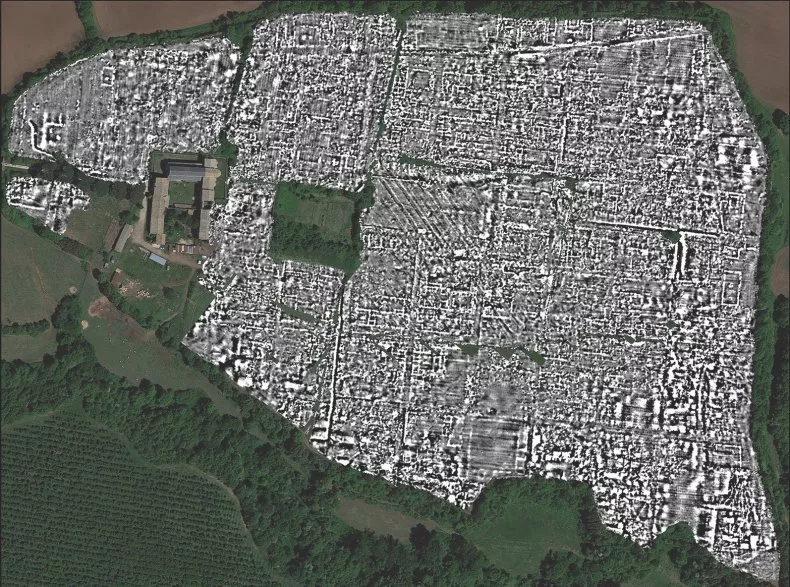
Ground-penetrating radar map of Falerii Novi, Italy.
L. VERDONCK ET AL./ANTIQUITY
"The main [recent] advances are in data processing and location technology—if you are collecting data at 6.25-centimeter spacing, then it is very important to be able to locate your position accurately," Millett said.
"The key finding is that we are able to map the whole town in great detail without digging. The brilliant quality of the very high resolution images that the technique produces surprises and amazed me! It is certainly the way of the future—providing information to help understand whole urban layouts quickly and without excavation," he said.
One of the benefits of this technology, is that it can reveal how a settlement has changed and evolved over long periods of time due to its ability to create a picture of the soil at different depths.
Millett and his colleagues have already used GPR to survey other sites, including Interamna Lirenas in Italy, as well as Alborough in North Yorkshire, England. However, the researchers hope that advanced GPR techniques can be applied to larger sites in other parts of the classical world.
"It is exciting and now realistic to imagine GPR being used to survey a major city such as Miletus in Turkey, Nicopolis in Greece or Cyrene in Libya", Millett said in statement. "We still have so much to learn about Roman urban life and this technology should open up unprecedented opportunities for decades to come."
Despite the promise of high-resolution GPR, the technique does pose some problems for researchers due the sheer amount of data that it produces.
Using traditional manual data analysis techniques, it takes around 20 hours to fully examine a single hectare, meaning it will take some time for the archaeologists to fully document Falerii Novi. As a result the team are trying to develop new automated techniques to help speed up the process.
"This produces a lot of data—28 billion data points—so the key is in the software and computer capacity," Millett said.
Falerii Novi was first occupied in 241 B.C. and survived until around A.D. 700. While the city lies underground, it is well-documented archaeologists have been studying it with other non-invasive techniques for decades. Nevertheless, the latest GPR research has provided archaeologists with a far more complete picture of the city.
Source: Paper.li


Comments